|
||||||||||||||||||
|
|
||||||||||||||||||
|
| ||||||||||||||||||

| ||||||||||||||||||


|
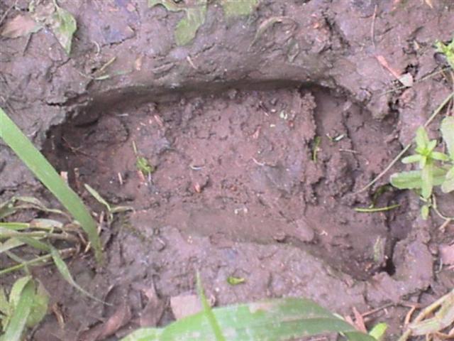
Geographical Index > United States > Texas > Denton County > Report # 23578 Report # 23578 (Class B) Submitted by witness on Thursday, April 10, 2008. Possible tracks found along the Greenbelt Corridor outside Denton (Show Printer-friendly Version) YEAR: 2008 SEASON: Spring MONTH: April DATE: 8 STATE: Texas COUNTY: Denton County LOCATION DETAILS: it was about 2 miles up river on the greenbelt not too far after you go under the railroad track off of 380. NEAREST TOWN: Denton NEAREST ROAD: 380 OBSERVED: I live in Frisco Texas, and me a friend go kayaking at the greenbelt quite often, Denton county, it connects lakes Lewisville and lake Rayroberts together, We started kayking and probably went about 2 miles when we came upon a log jam we could not get around. So we had to get off the water and go around it on the shore. When we were about to put our boats back in the water my friend yells for me to look at something and we came upon a series of unusual footsteps that looked non human but bigger then any other animal that is in this area. I did some research and noticed that there hasnt been any sightings in this area but these are very unusual human like animal tracks. I do have pictures. ALSO NOTICED: It could be just a coincendence, but after we left the area we kept going up river but when we turned around and came back by the spot you heard a wild pig squeeling in the around the same spot. OTHER WITNESSES: Yes my friend he was walking with his kayak in front of me. I was following. OTHER STORIES: No i did reasearch and could not find any other sightings in this area. TIME AND CONDITIONS: about 12:00pm it was a cloudy day turning into partly cloudy ENVIRONMENT: Swamp, Forest, near railroad. Follow-up investigation report:
|